The integration of advanced technologies has revolutionized mining practices, making them more efficient and sustainable. One category of technology that stands out in this arena is remote sensing, which enables data collection from a distance through various sensors. This blog post delves into the transformative role of remote sensing in open-pit mining, with a particular focus on its implications for tailings monitoring and management.
What is Remote Sensing?
Remote sensing refers to acquiring information about an object or phenomenon without making physical contact. This technology employs a variety of sensors, often mounted on satellites, aircraft, or drones, to collect data about the Earth's surface. The principles behind remote sensing involve emitting energy (e.g., light, microwave) and analyzing the reflected energy to gather information about geographic features, land cover, mineral composition, or temperature.
The history of remote sensing can be traced back to the early days of aerial photography, evolving significantly over the years. With the rising importance of effective tailings management to meet compliance metrics and prioritize safety, particularly in the face of potentially decreasing resources, remote sensing technology has become an invaluable tool for monitoring tailings facilities.
Types of Remote Sensing Methods in Mining
Aerial Surveys Using Drones
Drones (or UAVs) have high-resolution cameras or sensors that enable detailed mapping and monitoring of tailings storage facilities (TSFs). UAVs can capture near real-time imagery of tailings. By utilizing UAV surveys, engineers can detect changes in the topography of the tailings, assess water levels, and identify erosion or other potential risks, enhancing their safety management practices.
LiDAR
LiDAR technology is increasingly used in mining for precise topographical mapping and analysis. It uses laser pulses to create detailed 3D models of terrain and structures, including TSFs. This technology provides crucial elevation data for assessing tailings stability, detecting surface movements, and managing vegetation.
Satellite Imaging
Optical satellite imagery plays a vital role in remote sensing applications for mining, particularly in monitoring tailings. Satellite systems such as WorldView-3 provide high-resolution data essential for detailed topographical analysis of TSFs. These satellites can cover extensive areas and deliver periodic assessments, allowing for a comprehensive understanding of the evolving landscape.
Advantages of Remote Sensing over Traditional Survey Methods
Broad Area Coverage
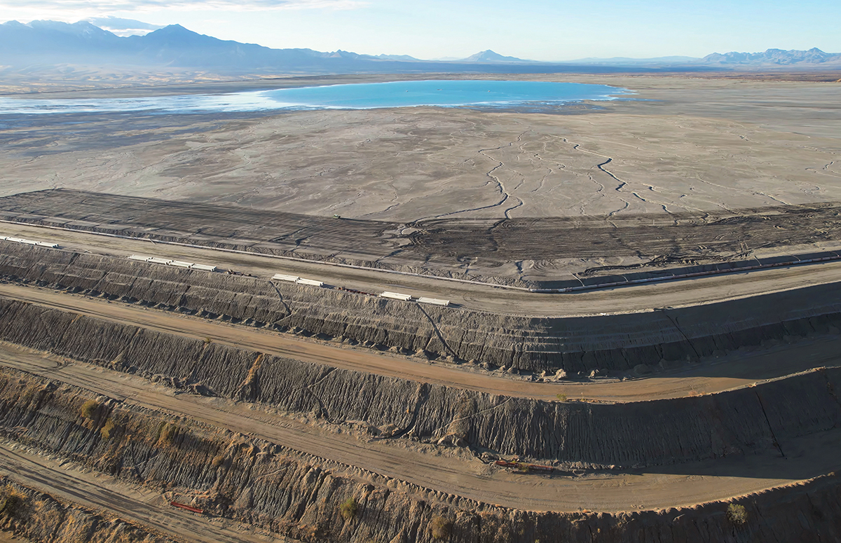
One distinct advantage of remote sensing is its ability to efficiently cover large areas. Traditional surveying methods often require significant staffing and are time-consuming. In contrast, remote sensing allows mining engineers to evaluate extensive tailings facilities in a fraction of the time. For example, a drone survey can cover several kilometres in a single flight, providing comprehensive data on the condition of tailings. Optical satellites can produce imagery that covers dozens of square kilometres, making it possible to assess the entire TSF in one image, a process that would take weeks or months with ground surveyors.
Regular Data Collection
Timely data is crucial in the mining industry, especially in managing tailings. Remote sensing technologies enable routine data collection, empowering engineers to respond promptly to emerging issues. Drones can monitor water levels, sediment displacement, and any unusual changes in the tailings structure, enhancing decision-making processes and operational efficiency. Optical satellites excel at monitoring tailings deposition volumes, beach lengths, deposition slope parameters, and water elevation measurements.
Enhanced Safety Measures
Safety is paramount in mining operations, particularly concerning tailings management. Traditional monitoring often necessitates personnel working in potentially hazardous environments. Remote sensing mitigates these risks by reducing the need for on-ground presence in high-risk areas.
During a tailings dam inspection, drones can quickly identify potential instabilities or structural deformations, leading to timely interventions and increased safety for both the workforce and the surrounding communities. Another example is the use of optical satellite imagery to monitor construction projects for compliance management. By providing regular updates on the progress and adherence to safety regulations, engineers can ensure that construction activities are conducted safely and according to compliance standards. This proactive oversight helps mitigate risks and ensures the safety of workers and the surrounding areas throughout the project lifecycle.
Challenges and Limitations of Remote Sensing in Mining
Despite its advantages, remote sensing also presents challenges. Data accuracy and resolution can vary depending on sensor capabilities and atmospheric conditions. Drones are dependent on battery life and operator access to a site. Depending on local laws, LiDAR relies on crewed aircraft that must seek special permits. Additionally, its data is quite dense and takes some time to process.
Optical satellites must contend with cloud cover and tasking queues, especially in high-demand areas. Regulatory and environmental considerations must also be navigated, as mining companies face closer scrutiny over their tailings management practices.
The Future of Remote Sensing in the Mining Industry
As the industry transitions toward sustainable mining practices, remote sensing will play a vital role in continuously monitoring the environmental impacts associated with tailings. This practice will help mitigate risks to local ecosystems and promote responsible mining activities. As remote sensing technology advances, it provides mining engineers with a powerful tool to enhance operational efficiency, safety, and sustainability.
With 70+ years of combined engineering and geology expertise in-house, and proprietary deep-learning processes, PhotoSat is the leading expert in satellite surveying, providing safe and responsible solutions for the entire lifecycle of a mine site, from exploration to closure.