
Engineering-Grade Deliverables from Remote Sensing Data
In mining operations, access to accurate ground insights has historically required physical site visits, field surveying, and significant logistical effort.
This can introduce delays, cost, and safety exposure – particularly in remote or complex environments.
Through the combination of Vantor’s high-resolution satellite imagery and PhotoSat’s proprietary deep-learning algorithms, remote sensing data is transformed into engineering-grade topographic and geological outputs that support planning and analysis without requiring a site visit.
Creating High-Accuracy Topographic Surveys from High-Resolution Satellite Imagery
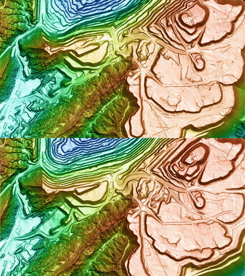
PhotoSat produces bare-earth surfaces (DEM/DTM) derived from 30 cm or 50 cm stereo satellite imagery, achieving vertical accuracies of 10 cm to 15 cm RMSE in bare ground areas when ground control is applied. These products can be generated over areas ranging from 1 sq.km to more than 1,000 sq.km and delivered in any file format and coordinate system.
This enables remotely collected, high-accuracy topographic surveying for mining operations, including geotechnical, water, and tailings engineers who require reliable spatial data across both localized and large-scale operational environments.
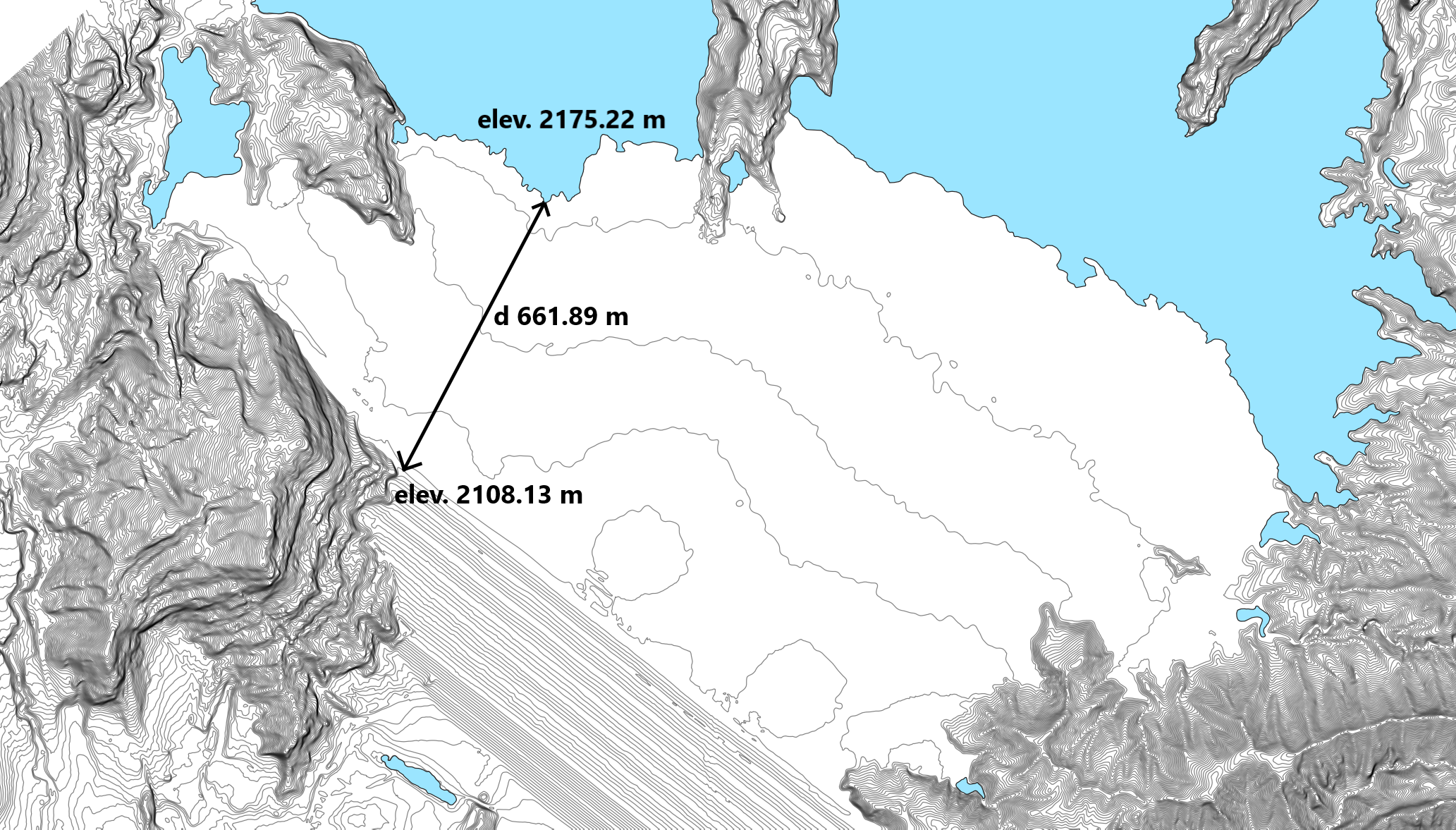
From an operational and engineering perspective, this capability enables systematic tracking of the development, spatial extent and volumetrics of tailings facilities, stockpiles, and waste dumps, along with pits, equipment staging areas, and site infrastructure. It also supports key engineering metrics including TSF capacity, outline and elevation of the supernatant pond, dam crest elevation, available freeboard, beach lengths, cross-sections, and cut-and-fill volumes, used in planning, as-built reconciliation, and compliance reporting.
Vantor, formerly known as Maxar Intelligence, provides the high-resolution satellite imagery that serves as the primary remote sensing data for these topographic surveys. Vantor’s industry-leading satellite constellation delivers nearly 7 million sq.km of daily collection capacity, including more than 3.5 million sq.km of imagery at 30 cm-class resolution. That collection power is paired with a 25-year archive of imagery, which provides critical temporal context for understanding terrain, surface change, site development, infrastructure, and reclamation progress over time. By delivering broad-area coverage with the detail needed to evaluate site conditions and track operations over time, Vantor and PhotoSat help sites build a more current, objective understanding of the ground, enabling faster planning, better development decisions, and more confident oversight across the mine lifecycle.
PhotoSat’s DEM/DTM proprietary generation workflows and customizable analytical products derived from elevation data, such as volume calculations and cross-sections, can be delivered on an ad-hoc or recurring basis depending on operational requirements.

Argus Surveys: Tackling Operational Challenges on Small, Dynamic Sites
Traditional survey methods are not always available at the required frequency, limiting the ability to detect operational risks or deviations from mine plans in a timely manner.
To address this, PhotoSat developed Argus Surveys, a high-accuracy, high-frequency satellite-based surveying solution for small to mid-sized operational areas. Argus enables focused survey coverage of 0 to 10 sq.km within a 25+ sq.km imagery capture collection area., and delivery within approximately three days of data acquisition.
Vantor’s 10 satellite constellation can revisit the same location on Earth up to 15 times per day, allowing for up to bi-weekly stereo collections over client sites. Collection windows are flexible to align with operational needs.
In addition to raw elevation and imagery, Argus can deliver the same add-on operational insights that support engineering decisions as described above, including geolocated water body outlines (e.g., supernatant ponds and seasonal accumulation zones), deposition maps tracking time-stamped volume changes across tailings facilities and stockpiles, beach length measurements, and profile lines capturing cross-sectional elevation, slope, and lift changes over time.
Alteration Mineral Mapping: Mineral Intelligence from Space
Beyond topography, PhotoSat and Vantor also enable property-scale alteration mineral mapping to support mineral exploration.
PhotoSat’s alteration mineral maps provide geologists with valuable insights which support regional-scale project generation or property-scale target generation without requiring site access. The data helps geologists make better data-driven decisions to shorten timelines and reduce expenses.
The property scale capability is enabled through Vantor’s WorldView-3 shortwave infrared (SWIR) satellite imagery, which collects spectral signatures of key alteration minerals that can be indicative of subsurface ore deposits. PhotoSat applies proprietary deep-learning models trained on an in-house spectral library gathered from a variety of case studies around the world to provide more accurate and reliable results compared to traditional off-the-shelf processing methods.
This workflow supports high-resolution alteration mineral mapping at a 2-meter resolution over project areas ranging from 50 sq.km to 1,000+ sq.km. The datasets are validated by geology analysts and delivered as interpretation-ready results to ensure spectral accuracy, technical compliance, and rigorous quality control.
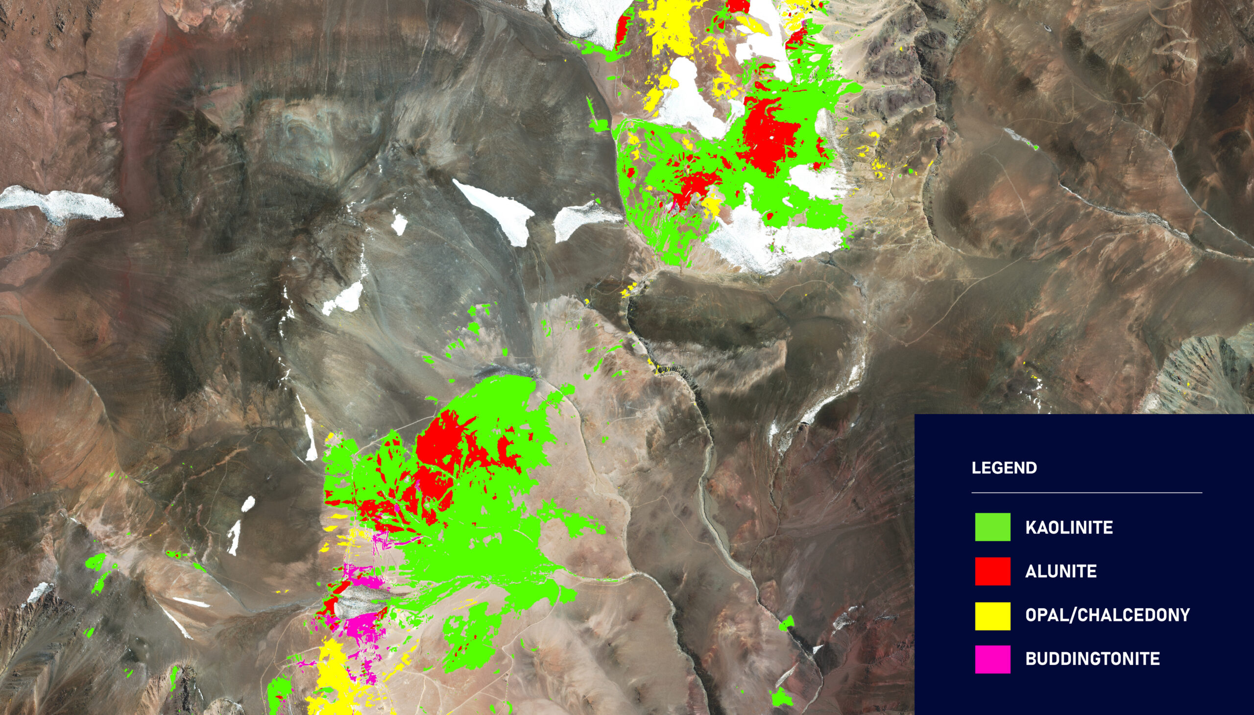
A strong example of this capability is the Filo del Sol project in Argentina, where a 100 sq.km area was analyzed using Vantor’s SWIR imagery. The work included 2 m alteration mineral mapping for 12 alteration minerals such as Alunite, Kaolinite, Opal, and Buddingtonite alongside 30 cm context orthophotos. The outputs were provided as interpretation-ready deliverables, which were ground validated through ground sampling and QA/QC workflows. This work enabled geologists to refine their exploration targeting and reduce early-stage uncertainty at an exploration project that became one of the largest gold-copper discoveries in the last decade.
Engineering the Future of Mining at Every Scale
The integration of Vantor’s high-resolution satellite imagery with PhotoSat’s in-house software and purpose-built analytical algorithms enables engineering-grade surveying and mineral intelligence without requiring physical site visits. Since 2018, our solutions have leveraged established machine-learning techniques, including convolutional neural networks (CNNs), trained on trusted and verified datasets. Outputs undergo continuous validation, expert oversight, post-processing, and rigorous quality control to ensure accuracy and confidence.
From topographic surveys and associated operations insights to regional-scale exploration mineral mapping, this partnership supports faster decision-making, reduces field risk, and improved operational efficiency across the mining lifecycle.
The Bottom Line: Safer, Faster, Smarter
The synergy between Vantor’s imagery and PhotoSat’s processing capabilities empowers mining and exploration teams to access geospatial information and derived insights, reducing the traditional trade-off between scale and accuracy. By reducing the need for frequent physical site visits, clients can make faster, more informed decisions while improving safety, efficiency, and operational oversight.
At PhotoSat, we believe that better data leads to better decisions. Whether tracking tailings deposition or mapping a regional mineral trend, our solutions complement fieldwork and other surveying methods as part of a broader toolkit for modern mining operations.
Start your next project phase with clarity. PhotoSat helps you define what is needed before each project phase, ensuring planning is built on accurate satellite-derived inputs. Connect with us today.
